Editor's note: Go here for the latest updates on Friday, Aug. 9.
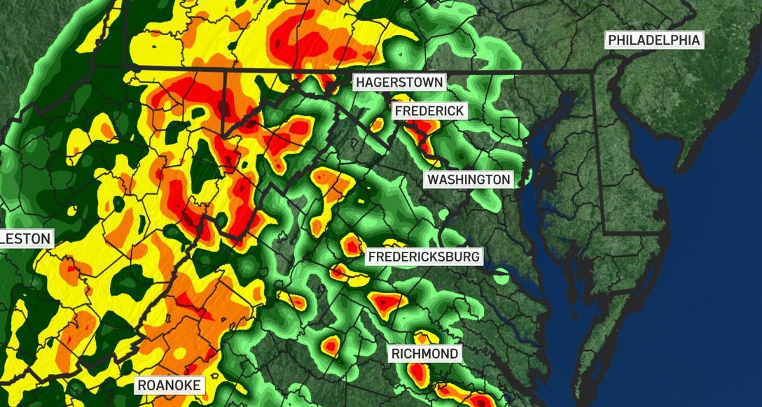
As Tropical Storm Debby bears down on the East Coast, the storm's remnants bring heavy rain and possibly flooding to the D.C. area. What's left of Debby will have the greatest effects through Friday morning. Be prepared for downpours, potential flooding and a small risk of tornadoes.
A tornado watch is in effect until 7 a.m. for D.C. and several counties in Maryland: Montgomery, Prince George's, Washington and St. Mary's. There's also a flood warning in effect until 11:15 a.m. (See more details and other weather alerts below.)
Prince George's County handed out sandbags to residents Thursday, a day after Alexandria did the same. The Maryland Department of Emergency Management said it's enhanced its emergency preparations stance, and Virginia Gov. Glenn Youngkin declared a state of emergency to mobilize equipment and resources.
Tornado watch issued for the DC area until Friday at 7 a.m.
A tornado watch is in effect until 7 a.m. for D.C.; several counties in Maryland — Montgomery, Prince George's, Washington and St. Mary's — and in Northern Virginia for the cities of Alexandria, Fairfax, Manassas, Manassas Park and Falls Church, plus the counties of Culpeper, Fairfax, Fauquier, Loudoun, Prince William and Stafford.
A tornado warning was in effect in Northern Virginia in Fauquier County, Loudoun County, Frederick County and Central Clake County until 10:15 p.m. on Thursday.
In Maryland, a tornado warning was issued for central Montgomery County until 6 p.m. Thursday, and early Friday, one was issued for Charles County, Maryland, but was cancelled about 5 a.m.
Flood watch issued in Maryland and Virginia
Keep an umbrella handy Thursday. Steady rain was already falling as of midday in D.C. More rain is expected to pick up overnight, and the worst downpours are expected Friday morning.
Heavy rain could quickly lead to flash and urban flooding, especially in areas prone to flooding like Alexandria, Virginia. Make sure your gutters and storm drains are clear.
Flood watches have been issued for some areas west of the District. Frederick, Maryland, and parts of Northern Virginia, including western Loudoun County and northern Fauquier County, will be under a flood watch from Thursday evening to Friday evening, the National Weather Service said.
Go here to see all weather alerts.

Storm Team4 says areas closer to the D.C. metro area could get flood watches as well. However, the rain is needed after D.C.'s dry summer.
"In our area, this is needed rain. Certainly, there could be some isolated flooding but nothing like what they're seeing down into parts of the Carolinas," Storm Team4 Meteorologist Amelia Draper said.
Weather Radar
Download the NBC Washington app on iOS and Android to check the weather radar on the go.
There's a "non-zero chance" for tornadoes as the remnants of the tropical storm near the D.C. area. Keep an eye out for tornado watches and warnings, and make a plan in case severe weather hits your neighborhood.
The rough weather could impact any travel plans.
Heavy rain and potential floods could slow drivers Thursday night and into Friday. Never drive into a flooded road. Remember: Turn around, don't down.
Wind restrictions are possible on the Bay Bridge. This storm could also have ripple effects on air travel, so check with your airline before heading to the airport.
The good news? This storm won't last too long. By Saturday, sunshine is expected to return, along with breezy conditions and highs in the 80s.
How can I prepare for Tropical Storm Debby?
- Make sure storm drains and gutters are clear
- Secure outdoor items such as trash cans and lawn chairs that could get knocked down or blown away
- Keep phones, tablets and laptops charged and have backup charging devices ready
- Have household and food supplies on hand, including medications and pet food
- Make sure cars are serviced and have a full tank of gas
- Have a family emergency plan in place in case of severe flooding and for potential future emergencies


