Editor's Note: To see the latest updates about this winter storm as it moves through our area on Saturday, click here.
Many residents of the D.C. area could see snowflakes this weekend — but cold rain in the forecast is washing out hopes for a winter wonderland near the Beltway.
Storm Team4 is tracking a winter storm expected throughout Saturday. Some snow is expected Saturday before it changes into all rain for much of the region. Highs will be in the mid- to upper 30s.
"We could see rain and snow coming down at a pretty good rate at times," Storm Team4 Meteorologist Amelia Draper said.
We've got the news you need to know to start your day. Sign up for the First & 4Most morning newsletter — delivered to your inbox daily. Sign up here.
Areas to the north and west of the D.C. metro area will see the largest effects of the storm. Loudoun County, Virginia, public schools canceled on-campus activities and announced administrative officers would be closed Saturday.
Storm Team4 predicts:
- Little to no accumulation in the D.C. metro area
- 1-3 inches of snow north and west of D.C.
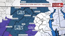
- 3 to 6 inches of snow and some ice in the I-81 corridor.

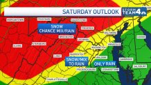
Here’s where snow and rain are expected
Weather
Latest weather forecast, live radar and weather maps for Washington, D.C., Maryland and Virginia
Red zone: Along the I-81 corridor and up to Frederick County, Maryland is where the storm will have the biggest impacts. Snow is expected to arrive in the morning and continue into the afternoon. Even in this zone, the storm will likely end with rain.
But there's also the chance for some ice in these areas north and west of D.C., including the Blue Ridge Mountains and the Hagerstown area.
Yellow Zone: Between Washington; most of Fairfax, Montgomery and Prince William counties and down through Stafford and Fauquier counties, expect a wintry mix.
“We're looking at a mix of rain and snow changing over to all rain by the midday and afternoon hours” on Saturday, Draper said.
Green zone: In southern Maryland, central and southern Prince George's County and up through Anne Arundel County, you're dealing with mainly rain.
“Could you see a few snowflakes? Absolutely,” Draper said. “But this is just going to be, for the most part, a rainy chilly day for those of you east of I-95.”
Weather radar
Download the NBC Washington app on Apple and Android to use the weather radar on your mobile device.
Timing and snow totals
By 9 a.m. Saturday, we’ll likely have a wintry mix across the area, dropping mainly wet snow around D.C. and areas to the north.
About midday, the rain and snow line is set to be in play right along the I-95 corridor. But the D.C. area can expect a shift to mostly rain in the afternoon.
Rain will exit as we head into nighttime, but there could be a lingering shower or some lingering snow showers out there on Sunday.
We're talking about a lot of moisture: Nearly an inch of precipitation could fall.
Unfortunately for snow lovers, most of this precipitation will be rain.
If this storm system was all snow, we'd be talking about nearly a foot of snow across the area. But surface temperatures will be too warm, among other factors.

Winter weather advisory issued for parts of Maryland and Virginia
A winter weather advisory will be in effect from Saturday morning through the evening in areas north and west of D.C., including:
- Culpeper County, Virginia
- Fairfax County, Virginia
- Fauquier County, Virginia
- Loudoun County, Virginia
- Prince William County, Virginia
- Spotsylvania County, Virginia
- Stafford County, Virginia
- Howard County, Maryland
- Montgomery County, Maryland
Roads could be slippery in these areas, the National Weather Service warned.
A winter storm watch was issued for the I-81 corridor, including Winchester and Luray.


