
4 things to know about the weather
- Feeling Like Winter Today
- Cold Wind And PM Raindrops
- Dry For The Weekend
- Easy Travel Weather
The wind never went to bed last night so you should be ready to bundle up for the chill right away.
Wind chills will be in the low to mid-20s Friday morning and hover near the freezing mark all afternoon thanks to a gusty northwest wind. Temperatures also won't move much, starting in the 20s and 30s and only getting a degree or two above 40°.
We've got the news you need to know to start your day. Sign up for the First & 4Most morning newsletter — delivered to your inbox daily. Sign up here.
The next thing to plan for is a rain chance this afternoon and evening. Rain is expected to arrive around noontime and is not likely to end until nearly midnight. Rain totals will be around a quarter-inch with lower amounts south of the Interstate 66 corridor.
Weather radar
Download the NBC Washington app on iOS and Android to check the weather radar on the go.
Snowflake watch
Wet snow could fall in the northern D.C. Metro area. Snowflakes are most likely as the storm begins around noon, when temperatures are colder.
Areas as far south as southern Montgomery County could see some flakes. It likely won't stick to the ground, but it will be enough to get people talking.
By the late afternoon and evening, the entire D.C. area will just see rain.
Thanksgiving week forecast
The weather will improve for the weekend and the getaway days leading into Thanksgiving.
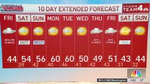
Saturday will remain quite cloudy and breezy with afternoon highs getting just above 50°. Sunday will have even more sun and less wind with highs reaching the upper 50s.
Monday will be sunny and mild. Clouds, and a small rain chance, will return on Tuesday. Wednesday will be chilly and dry.
Thanksgiving and the day after still look cold and wet. A more significant cold snap will arrive for the weekend after Thanksgiving, keeping temperatures at least 10° below average for the first week of December.


10-day forecast
Quickcast
TODAY:
Cloudy, Cold, Gusty
Rainfall Around 1/4"
Periods Of Wet Snow Possible
Wind: West 14-26 mph
Chance Of Rain: 80%
HIGHS: 38° - 44°
TONIGHT:
Cloudy, Cold, Gusty
Showers Before Midnight
Dry By Morning
Chance Of Rain: 80%
Wind: Northwest 14-26 mph
LOWS: 36° - 42°
SATURDAY:
Partly To Mostly Cloudy
Gusty
Not As Cold
Wind: Northwest 15-30 mph
Chance Of Rain: 0%
HIGHS: 50° - 55°
SUNDAY:
Partly Cloudy
Seasonable
Breezy At Times
Wind: Northwest 10-20 mph
Chance Of Rain: 0%
HIGHS: 52° - 58°
MONDAY:
Sun and Clouds
Milder
Light Breeze
Wind: Southwest 5-10 mph
Chance Of Rain: 0%
HIGHS: 60° - 65°
Sunrise 6:59 Sunset 4:50
Average High: 56° Average Low: 40°