
4 things to know about the weather:
- Small Rain Chance This Afternoon
- First 80s of 2025 Tomorrow
- Really Warm Sunday Too
- Rain Likely Monday
A surge of warm air is heading our way and will push temperatures about 20° above average for the upcoming weekend. The warm air arrives with the passage of a warm front Friday afternoon.
We'll start out the day with temperatures in the 40s and some sunshine. Clouds will thicken before noon and there will be a chance of rain, nothing heavy or long-lasting, between about 2 and 8 p.m. Even with the clouds, temperatures will climb well into the 60s.
We've got the news you need to know to start your day. Sign up for the First & 4Most morning newsletter — delivered to your inbox daily. Sign up here.
Southwest winds overnight will hold temperatures in the mid- to upper 50s. That mild start on Saturday will be just the beginning of weather more typical for Memorial Day than late March.

Clouds will give way to increasing sunshine Saturday afternoon. Most of the area will reach at least 80° with a few mid-80s in metro D.C.
Clouds will thicken Saturday night, keeping many areas above 60°. Sunday will come with plenty of clouds and a strengthening southwest wind. Most of the day will remain dry but rain chances will begin to increase by late in the afternoon.
Highs on Sunday will once again get close to 80°.
Hit and miss showers Sunday evening will turn into a likelihood of rain by Monday afternoon with highs remaining in the 70s.
Tuesday and Wednesday will be much cooler and dry, with highs staying in the 50s.
Weather radar
Download the NBC Washington app on iOS and Android to check the weather radar on the go.
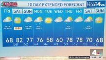
10-day forecast
Quickcast
TODAY:
Mostly Cloudy, Milder
Dry Before Noon
Scattered Showers After 2PM
Wind: Southwest 8-18 mph
Chance Of Rain: 60%
HIGHS: 64° - 70°
TONIGHT:
Mostly Cloudy
Dry After 9PM
Remaining Mild
Chance Of Rain: 20%
Wind: Southwest 5-10 mph
LOWS: 54° - 58°
SATURDAY:
Some Morning Clouds
More Sun After Noon
Breezy, Much Warmer
Wind: Southwest 10-20 mph
Chance Of Rain: 0%
HIGHS: 78° - 84°
SUNDAY:
Mostly Cloudy
Warm And Breezy
Scattered Showers After 4PM
Wind: Southwest 12-22 mph
Chance Of Rain: 20%
HIGHS: 74° - 78°
MONDAY:
Cloudy, Breezy & Mild
Rain Up to 0.50" Likely
Isolated Thunderstorms
Wind: Southwest 15-25 mph
Chance Of Rain: 80%
HIGHS: 70° - 78°
Sunrise 6:59 Sunset 7:28
Average High: 61° Average Low: 42°