
4 things to know about the weather:
- Sunshine with warmer temperatures to wrap up the weekend.
- Isolated showers overnight.
- Warm start to the week ahead, cooling off mid-week.
- Needed rainfall returns late Monday and into Tuesday.
After a cooler, grey Saturday, Sunday will bring out sunshine and warmer temperatures in the afternoon.
Temperatures will start out in the 50s in the morning before climbing up to the 60s. Expect temperatures to reach 62°.
We've got the news you need to know to start your day. Sign up for the First & 4Most morning newsletter — delivered to your inbox daily. Sign up here.
Sunshine will break through throughout the morning and afternoon hours as an area of low pressure that brought us all of that rainfall and gloomy weather is now moving out.
There's a chance of isolated showers Sunday night through the early morning hours of Monday.
Weather to improve on Sunday
Even warmer temps are on tap to start out the workweek.
Monday will be the nicest of the next four days as temperatures reach the low-70s. Most of Monday will be dry but a cold front Monday night might bring a stray shower or two as it passes.
There might be morning showers on Tuesday with high temperatures still in the mid-60s but falling into the mid-50s Wednesday.
The D.C. area will see warmer temperatures again on Thursday and Friday with highs nearing 70°.
Weather radar
Download the NBC Washington app on iOS and Android to check the weather radar on the go.


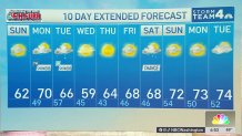
10-day forecast
Quickcast
SUNDAY
Decreasing AM Cloud Cover | Sunny PM | Warmer
HIGHS: Lower 60s
WIND: NW 10-15+ MPH
SUNDAY NIGHT
Cloudy | Isolated Showers
LOWS: Upper 40s (Suburbs) to 50s (Downtown)
MONDAY
Mostly Cloudy | Warm | Showers and Iso. Storms Late PM
HIGHS: Near 70F
TUESDAY
Showers Ending
HIGHS: Middle 60s
WEDNESDAY
Mostly Sunny | Cool
HIGHS: Near 60F
THURSDAY
Mostly Sunny
HIGHS: Middle 60s