


4 things to know about the weather:
- March lion still roaring
- Freeze threat Wednesday night near I-81
- Big warmup ahead
- Weekend rain chances dropping
Thanks to just recording the fourth warmest March on record, it already looks like May, but the calendar still says April and those strong, northwest winds will have it feeling more like March Wednesday afternoon.
All three of our major airports recorded wind gusts over 50 mph on Tuesday. DCA was 52 mph, IAD was 55 mph and BWI was 51 mph. The gusty wind has lost a little bit of its punch but you will still consider Wednesday to be more than just a little bit breezy.
We've got the news you need to know to start your day. Sign up for the First & 4Most morning newsletter — delivered to your inbox daily. Sign up here.
Northwest winds will average around 20 mph and still gust over 30 mph quite frequently. Combine that with temperatures staying in the 50s for most of the afternoon and some clouds from time to time and you’ll want to have that spring jacket at the ready.
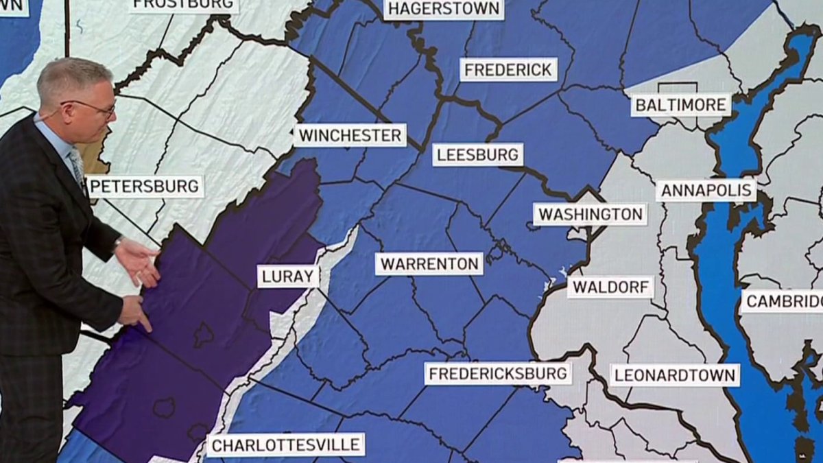
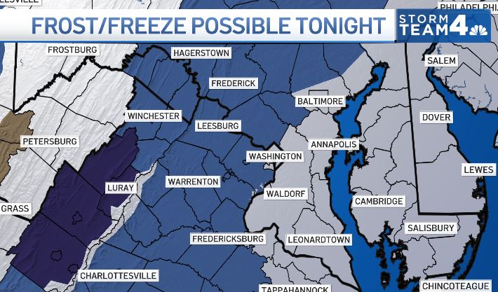
Skies will clear Wednesday evening and the wind will settle down some after 9 p.m. to 10 p.m. Temperatures will drop into the 30s for most of the rural areas and there will be the risk of a freeze for the central and southern Shenandoah Valley by Thursday morning.

High pressure will bring us a sunny and mild Thursday afternoon with light winds and highs getting close to average.
Weather radar
Download the NBC Washington app on iOS and Android to check the weather radar on the go.
Temps could reach over 80° on Saturday
As that area of high pressure moves out to sea, our winds will increase from the southwest for Friday and Saturday. Even with increasing clouds, temperatures will soar into the mid-to-upper 70s on Friday and the mid-80s on Saturday.
Some of our forecast models hint that D.C. could be as warm as 87°-88° on Saturday! No, that won’t be a record. D.C. has been 90° or higher six times on April 19, most recently reaching 91° back in 2004. Even Dulles’ record is above 90°.
A cold front will sag southward by late Saturday afternoon so there will be a small chance for a shower or two but rain chances are less than 20%.
Sunday will be about 10° cooler and also come with a non-zero chance of a rain shower. Higher rain chances and highs staying in the 60s will come on Monday.

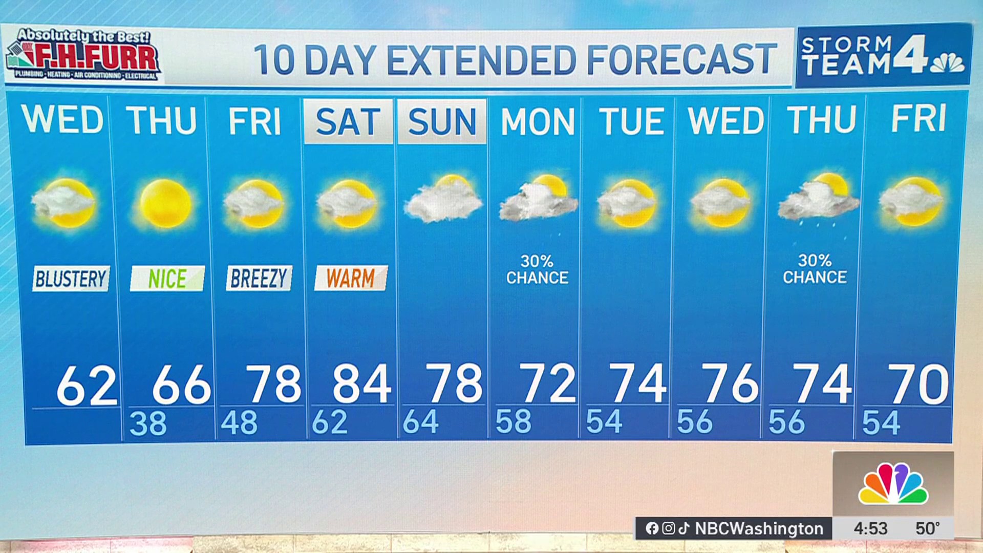
10-day forecast
Quickcast
WEDNESDAY:
Cool & Blustery
Midday Cloudiness
Staying Dry
Wind: Northwest 15-30 mph
Chance Of Rain: 0%
HIGHS: 56° - 62°
WEDNESDAY NIGHT:
Becoming Clear
Breezy Evening
Freeze Threat Near I-81
Wind: Northwest 5-15 mph
Chance Of Rain: 0%
LOWS: 36° - 42°
THURSDAY:
Mostly Sunny
Seasonably Cool
Nice Breeze
Wind: Northwest 8-12 mph
Chance Of Rain: 0%
HIGHS: 60° - 65°
FRIDAY:
Partly Cloudy
Warmer
Breezy Afternoon
Wind: Southwest 12-24 mph
Chance Of Rain: 0%
HIGHS: 72° - 78°
SATURDAY:
Mostly Cloudy
Breezy & Very Warm
Slight PM Shower Chance
Wind: Southwest 12-22 mph
Chance Of Rain: 10%
HIGHS: 78° - 84°
Sunrise 6:30 Sunset 7:46
Average High: 68° Average Low: 49°

