
Storm Team4 is tracking heavy rain with the potential to cause flooding in the D.C. area Sunday and turn into snow overnight.
A flood watch is in effect for excessive rainfall in parts of D.C., Maryland and Virginia until 1 a.m. on Monday. Go here for all weather alerts.
“It’s really the chance of flooding this afternoon that has our concern,” Storm Team4 Meteorologist Ryan Miller said.
We've got the news you need to know to start your day. Sign up for the First & 4Most morning newsletter — delivered to your inbox daily. Sign up here.
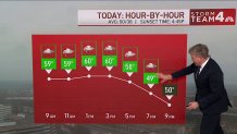
Rain began falling early Sunday. Heavy rain began around noon and will continue through midnight. Gusty winds up to 35 mph are possible.
The greatest potential for flooding is in areas along and east of Interstate 95, Miller said. Close to two inches of rain could fall in the Metro area.
Temperatures are expected to climb to the lower 60s during the day. A cold front will move into the western viewer area by 7 p.m. This will turn some of the rain into snow overnight and into Monday morning.
“A very mild day ahead of the cold front that’s ultimately going to give us the colder air,” Miller said.
Local
Washington, D.C., Maryland and Virginia local news, events and information


Some light snow accumulation may be visible on grassy surfaces in D.C. While the northwestern suburbs could see a bit of snow into the early morning hours, according to Miller.
There will be precipitation early Monday, but it will quiet down quickly. Expect wet roads during the morning commute.
Stay with News4 for updates for this forecast and check out our weather page for radar and more weather info.